Results 1 to 1 of 1
Thread: Oh My, How You've Grown
-
2012-09-19, 12:47 PM (ISO 8601)Pixie in the Playground


- Join Date
- Nov 2011
 Oh My, How You've Grown
A while back i posted about this campaign world i wanted to create. Well, I did it. It has gone through two increasingly refined iterations, and is now in the beginning of its final(nothing is final) form.
Brief history of player involvement:
SpoilerWhere to start? My players have witnessed the return of the Chromatic Dragons (who slept themselves into myth and legend), helped to reunite 2/3 of The Grand Kamali Empire, given battle to the first Jager Orcs (Inspired by Girl Genius), and discovered the true nature of the Warrior Goddess Morrigan who drives her people to conquer the known world and hunt down the last of the Chromatic Dragons. In their glorious self-sacrificing attempt to trap Morrigan once and for all they, themselves are trapped (because she's a wily one) and bound in her demiplane prison. As time passes slowly for the trapped heroes, it moves more quickly on the material plane as ten years pass to the heroes two. Rescued by their cohorts, they find themselves in a world devestated by war and the collapse of the Grand Kamali Empire. Now, to set things right, they venture forth to establish a new home, and scour evil and villainy from their soiled homeland!
The Setup:
Big thank-you to Gabe & Tycho from Penny-Arcade for writing about Westmarches campaign design, and http://arsludi.lamemage.com/ for the awesome awesome concept.
That being said, i am making my ENTIRE WORLD a hex-grid map.
Entire World
Spoiler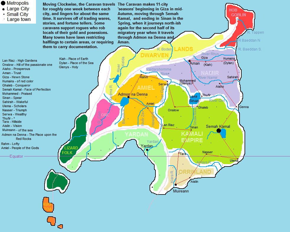
Actual Map (primarily the red region on World Map)
Spoiler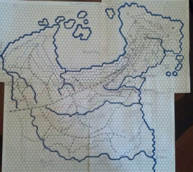
Map Notation:
SpoilerThere are lots of lines, yes, but don't be afraid. They are your friends.
First, notice the long line that runs through the length of the map. lower left to top right. It's a dash line that is crossed twice in each dash. That is a High Ridge. Those springing from it with singly crossed dashes are low ridges. The purpose for this: mountains are visible at great distances, but they block line of sight. One must be on a high ridge to see over a low ridge, but from a low ridge one cannot see over a high ridge. got it? great.
Small circles dot the map, these are the locations i've allotted for dungeons and that sort of thing. Many are active Fortresses or towers, while some are simple safe-houses or Ruined Castles, even towns.
Thick blue lines are the ocean/rivers. derp.
thin lines of various colors denote average elevation.DO NOT BE DECIEVED BY THE THIN BLUE LINE! IT IS NOT A RIVER! oversight on my part.
Here's the deal. PC's are brought back to the material plane and given the task of finding a new home. VERY conveniently one of the PC's noble father had a bitchin' castle nearby to their re-emergence point. The Cloud Giants, who have been so gracious as to put up a few NPC's, the Cohorts, and a few commoners who fled the devestation, are now thinking "hey, you, get off of my cloud-island" Rolling Stones style. Once they (of course) take the castle back from the local hobgoblin hordes, the ball's in their court.
Movement is (so far) strictly overland. from one hex to another is 4 miles, or about one hour of unimpeded travel by foot. This really brings the scale of the adventure into perspective. Whereas I could ballpark a travel time, now, I have exact hours. A control-freak DM's dream map.
ENCOUNTERS
SpoilerEncounters come in two ways: first is your established X-marks-the-spot type of dungeons, caves, what have you. Even bits of difficult terrain are marked as such. Secondly, and just as important is my random encounter table(s) which are still under construction and revision and revision and revision. I have structured the tables by the areas the PC pass through, with three distinct types and how each type interacts with the others.
Region: The overall makeup of an area, ie. Highlands, Plains, Mountains, Hills. This is the canvas on which i build the encounters.
Sector: That creepy forest, the miles of haunted marshland, a valley of scorched earth inhabited by awful demons. very specific and cohesive tables that make any one area more or less dangerous than the surrounding world.
Course: Highways, rivers, roads, game trails. a much higher chance of encountering travelers, caravans, or in the case of rivers, fish, trees that allow for river crossing, etc. they're like sectors, but they cover long, narrow areas and require a diffrent kind of roll.
Each of these overlaps, but they build on each other. i'm looking at an 80:20 chance of rolling up something from whatever type of hex a player is in, with the 20 being either a roll double or something from another acceptable table.
Honestly, the scale is breathtaking. it's going to cover my dining room table twice over. I estimate the N/S length of my continent/island to be around 700-750 miles. that translates to nearly 11 degrees of latitude. With some funny weather I can have cold ass Polish Winter North and The south of France and Mediterrania as my southernmost climes.
We'll be on this map for a while.
I'm in the process of grading the CR of each region(which are gated through any means I can devise short of saying "NO, you can't cross the river there"
I really really would like some feedback, insights, questions. I really can't talk to my players about this because they're going in blind, with a half-filled small regional map
Last edited by Big Meany; 2012-09-19 at 03:04 PM.

 Reply With Quote


 RSS Feeds: