Results 1 to 14 of 14
Thread: PTU: Creating my map
-
2017-09-01, 08:09 PM (ISO 8601)Pixie in the Playground

- Join Date
- May 2015
- Location
- Canada
- Gender

 PTU: Creating my map
Just thought I'd share my map with yall, tell me what you think of it =D
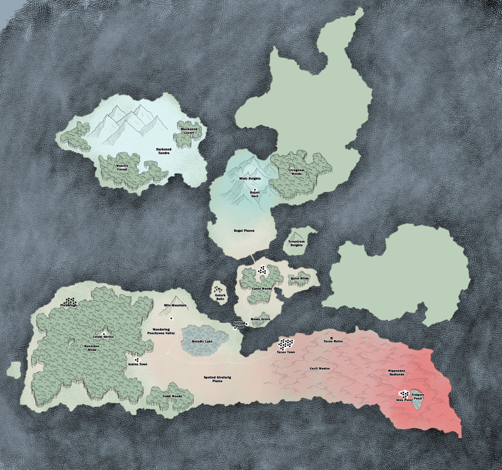
To view it full-size click hereDetermination is never useless.
-
2017-09-02, 04:09 AM (ISO 8601)Bugbear in the Playground

- Join Date
- Apr 2011
- Location
- Unknown
- Gender

Re: PTU: Creating my map
I really like your colors and the overall design of the map. Great background, wonderful landmass shapes.
I do a lot of maps, so I tend to over-analyze things with regards to climate, geography, and such. If you want a real critical response, just say so. I like the map, but it could use A TON of work to be even better.Ninjadeadbeard's Extended Homebrew Originally Posted by Zap Dynamic

-
2017-09-03, 05:57 PM (ISO 8601)Pixie in the Playground
- Join Date
- May 2015
- Location
- Canada
- Gender
Re: PTU: Creating my map
Thank you for your kind words! This map is for my Pokemon Tabletop campaign and so I'm going more by the Pokemon world's standards of climate - one city can be cold, the next sweltering. There's no real rhyme or reason to which areas are hot and which are not. That aside I'd love to hear your input on geography and what else I could slip into my map, I'm having quite a bit of fun designing it. Originally Posted by Ninjadeadbeard
Thanks again, looking forward to hearing from you.
PS. The dark leather-looking texture between islands isn't water, it's void - nothingness. These are all floating islands.Last edited by Niiohontesha; 2017-09-03 at 05:58 PM.
Determination is never useless.
-
2017-09-03, 10:33 PM (ISO 8601)Bugbear in the Playground
- Join Date
- Apr 2011
- Location
- Unknown
- Gender
Re: PTU: Creating my map
Well in THAT case you really shouldn't care about realistic geography at all. The only point I could make that you could use would be to add mountains to each of the islands that currently lack them. Beyond that, your central, vertical island appears to reach further north than your western one, but it doesn't appear any colder at all. In fact, it seems warmer. Originally Posted by Niiohontesha
Anything else I could add would highly depend on latitude, wind direction, and this being a realistic world. What latitude does your horizontal/desert island lie on, by the way? It doesn't really matter, but at certain latitudes the "desert" part would swap sides.
Yeah. This ^ means you shouldn't worry too much.PS. The dark leather-looking texture between islands isn't water, it's void - nothingness. These are all floating islands. Ninjadeadbeard's Extended Homebrew Originally Posted by Zap Dynamic
-
2017-09-04, 03:54 PM (ISO 8601)Pixie in the Playground
- Join Date
- May 2015
- Location
- Canada
- Gender
Re: PTU: Creating my map
Done and done! =D Originally Posted by Ninjadeadbeard
Wonderful, I wound up adding a new mountain range/volcano into the desert. Been working pretty hard on it so far. Originally Posted by Ninjadeadbeard
Ah yes, the central vertical island seems like it's warmer but I've actually forgotten to colour it in, haha. I will fix this. (Eventually) Originally Posted by Ninjadeadbeard
What do you mean at certain latitudes the "desert" part would swap sides? Originally Posted by Ninjadeadbeard
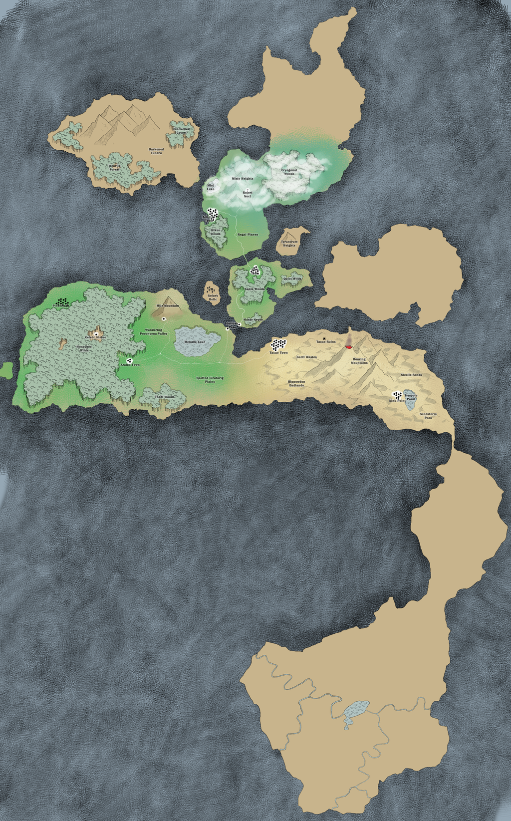
Click here for full-size map
I still need to colour in the landmass for most areas but I'm mainly focusing on drawing locations, forests mountains and stuff. As well as designing encounters for my campaign
Spoiler: Details on locations of map~Mile Mountain: Small mountain with a few sparse caverns and steep cliffs.
Wandering Poochyena Valley: A valley filled with hyena Pokemon.
Melodic Lake: A somewhat large lake filled with various sparkling Pokemon.
honeybee Wilds: A large forest with a shrine to Celebi nestled within. Large bees guard this area.
Azalea Town Ruins: A town from Johto that was transported here. It's left in shambles.
Teddi Woods: Filled with bears who are too scared to live in the large forest with the abundance of bees. They often make raids for the honey from their safe little forest.
Spotted Girafarig Plains: Spotted Girafarig Plains <3.
Tacae Town: A town home to a small police force and many buildings made from stone.
Cacti Wastes: Known for vicious cacti, trainers beware.
Tacae Ruins: Ancient ruins that have just been opened to explore.
Hippowdon Badlands: Deep sand home to many dangerous sand hippos.
Roaring Mountains: A volcano said to be the birthplace of Entei in this region. It was previously called Iter Mountain before it erupted.
Steelix Sands: Territorial Steelix guard the sands in this location
Nink Point: Home of Ronald Nink - related to the man who founded this little town.
Tympole Pond: A small body of water home to thousands of typole and evolutions. Many have gained new types and abilities and Professor Nink often hands them out to trainers
Sandstorm Pass: Many Flygon call this small area their home and as such a sandstorm is almost always brewing.
Pinebrugh: A town west of Honeybee Wilds, known for their excellent honey gathering skills they are the top distributor of honey. Not sure what else I'll put there yet.
Golliusk Pass: A Goliath Pokemon serves as transportation between the two islands as there has not yet been made a bridge
Mossy Grove: Many mushrooms. Many many mushrooms.
Canis Woods: Home to many canine pokemon, Berk town has dog shows with all their pokemon.
Berk Town: Small town on the way to Regal Planes, known for doggos
Regal Planes: Planes filled with lions =D
Silken Woods: Woods filled with brood mother spider and many spiderlings. Super dangerous.
Quiet Wilds: A forest that is unnaturally quiet. It's as if there's an enchantment snuffing out all sound here. Something mysterious brews in this forest.
Achnida Town: Town known for silken clothes and hikers.
Mist Lake: Home of Suicune, it's rare but one has been spotted.
Misty Heights: A larger mountain range with unnatural fog causing travelers to quickly become lost. All technology on this mountain shuts off for some reason.
Cryogonal Woods: Icy woods home to many giant sentient snowflakes
Tyrantrum Heights: A mountain range filled with various dinosaur Pokemon. It's somewhat of a challenge for trainers to climb the mountain and defeat the shiny creature at the top.
Darkened Tundra: Home of many mamoswine and piloswine, this tundra is overcast with violent storms.
Blackened Covert: A very dark forest with plenty of cover. It almost feels like night when you enter.
Weavile Forest: A dangerous forest filled with very vicious Pokemon. Locals suggest you do not enter.
Rumbling Peaks: Atop this mountain rages a thunderstorm, lightning crashes down into the peaks constantly and so the rumbling can be heard for miles. It's said Raiku lives up there.Determination is never useless.
-
2017-09-05, 01:47 AM (ISO 8601)Bugbear in the Playground
- Join Date
- Apr 2011
- Location
- Unknown
- Gender
Re: PTU: Creating my map
At the equator, the wind currents move east to west and generally towards the equator itself. This reverses around 30 degrees latitude, a region called the Horse Latitudes. Land along this latitude is dryer than one might expect, but rain shadows are still a thing so certain sides of certain continents will have different dryness/wetness balances. Example: The Sahara Desert. Originally Posted by Niiohontesha
Ninjadeadbeard's Extended Homebrew Originally Posted by Zap Dynamic
-
2017-09-05, 12:47 PM (ISO 8601)Barbarian in the Playground
- Join Date
- Mar 2016
Re: PTU: Creating my map
That's also assuming the planet this takes place on is roughly Earth size. That's a fair assumption given the pokemon reference, but I'd like to dork out about how larger spheres can have additional convection cells with more complex prevailing winds. Originally Posted by Ninjadeadbeard
The other climate detail that matters for a desert is that the prevailing wind passed over mountains at some point. The side of a continent that's down wind is going to be at least a little bit drier by nature of some of the rain having already fallen on the way over there, but it takes the Himalayas to create the Sahara, which is kind of weird because the wind does this little dip South to make that happen. You'd expect the Arabian Sea to march lots of clouds over that desert is prevailing winds perfectly kept the the latitudes they're supposed to occupy, but for the map making purposes we've got that big conceptual mountain somewhere roughly upwind from the sweltering desert.Last edited by Zorku; 2017-09-05 at 12:47 PM.
-
2017-09-05, 01:11 PM (ISO 8601)Barbarian in the Playground

- Join Date
- Nov 2016
- Location
- SoCal
- Gender
Re: PTU: Creating my map
Let me start by saying you have a nice looking map there. Well done.
Critical Feedback: Towns.... You have several towns. My issue I guess is what it might imply.
1) No cities? If there are cities why are they not on the map. If the towns are actually cities, having them all be called town is off putting a bit.
2) Are there other towns? What about villages? Is it a level of detail still to be filled in?
Secondary Feedback: Names might need to be raised up a notch.
is there going to be a player's map and a DM's map?
How about historical maps for the DM: Mostly for political reasons but to chart major shifts/trends. Maybe things like ancient keeps that are no
longer around or known about.
Keep going. Allow for changing names and terrain as you see what works and doesn't as you go along.
-
2017-09-05, 01:42 PM (ISO 8601)Barbarian in the Playground
- Join Date
- Mar 2016
Re: PTU: Creating my map
Pokemon seems generally quiet on the ruined keeps stuff. They make great sides for adventurers, but tend not to work so well with the discovering wildlife motif. I imagine this map will have a lot more stuff going on in forests, on mountainsides, and in caves. Almost like a planar adventure scaled from level 1.
-
2017-09-05, 08:57 PM (ISO 8601)Pixie in the Playground
- Join Date
- May 2015
- Location
- Canada
- Gender
Re: PTU: Creating my map
That's super interesting! I'm not sure if I'm going to follow realistic world 100% but I'm definitely going to keep this in mind! Originally Posted by Ninjadeadbeard
Actually the way I'm imagining this world is... Ah let me draw it Originally Posted by Zorku
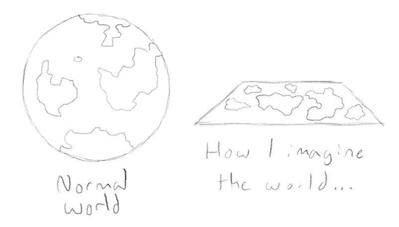
I imagine that this world is a near infinite plane stretching over the void.
I'm thinking about using minecraft logic in sky islands where when the sun is above it is daylight but when it goes beneath it's dipped too far into the void and lets no light through.
The more I think about it the less sense it makes but I'm still happy with the design of this world.
On another note: I could make certain islands at different altitudes but it's difficult to show in my aerial view.
-----
I was thinking of having one major city located in the Southern portion of the map. There are mostly towns in my map due to how dangerous the wild is and that humans haven't been in this region for too terribly long. Plus it's pokemon. Most locations in Pokemon are towns. Originally Posted by FreddyNoNose
Haha, don't like my names? I'm fine with them. I could go ahead and change them but I'm going for a silly cheesy vibe. Thus Berk Town. Right above Canis Forest. bark... canine... aha I'm too funny. Originally Posted by FreddyNoNose
That's actually a really good question. I should make a players map that details less. Should be good. For now I've been showing them this map and keeping all of my notes on the side. Originally Posted by FreddyNoNose
This world is changing, there's some hullabaloo about spatial rifts opening and bringing in locations from other places in the Pokemon Universe so places are appearing here and there where they weren't before. This is nice because it allows me to change things up if they're back tracking. Originally Posted by FreddyNoNose
Having quite a spot of fun discussing this with you all. Thanks for your comments and questions. I believe I've responded to everything. :)Determination is never useless.
-
2017-09-06, 01:06 AM (ISO 8601)Barbarian in the Playground
- Join Date
- Nov 2016
- Location
- SoCal
- Gender
Re: PTU: Creating my map
I know almost nothing about pokemon. Gigglypuff is a character. Is Shoe one or was that from South Park? Originally Posted by Niiohontesha
Last edited by FreddyNoNose; 2017-09-06 at 01:07 AM.
-
2017-09-06, 01:37 AM (ISO 8601)Pixie in the Playground
- Join Date
- May 2015
- Location
- Canada
- Gender
Re: PTU: Creating my map
Bunch O' magical animals living everywhere Originally Posted by FreddyNoNose
Dark magical monster threatens to destroy shizz
Evil organization getting into trouble
That's the basis of my campaign ;DLast edited by Niiohontesha; 2017-09-06 at 01:38 AM.
Determination is never useless.
-
2017-09-06, 09:45 AM (ISO 8601)Bugbear in the Playground

- Join Date
- Jun 2013
- Location
- Howard, NY
- Gender
Re: PTU: Creating my map
As I started reading, I saw the top half of the first version and thought "Gee, Ireland is big."
-- JoeShared pain is diminished. Shared joy is increased.-- Spider RoninsonAnd shared laughter is magical
Always remember that anything posted on the internet is, in a practical if not a legal sense, in the public domain.
You are completely welcome to use anything I post here, or I wouldn't post it.
-
2017-09-07, 05:54 PM (ISO 8601)Barbarian in the Playground
- Join Date
- Mar 2016
Re: PTU: Creating my map
Flatlands are a fine concept for these kinds of games. Good thing I mentioned that the weather patterns thing was globe dependent I guess. Originally Posted by Niiohontesha
If you want to depict the relative height of islands that are on a flat plane, there's an easy technique you could steal from a lot of space games. They draw a little dot on the center of mass and then have a line that shoots straight down (or up) to the point where it intersects with the plane, where they draw a little shape.
You can see it in faint lines if you look real close at the stars here: https://i.ytimg.com/vi/HOwSHm0vx5o/maxresdefault.jpg

 Reply With Quote


 RSS Feeds: