Results 61 to 81 of 81
Thread: Ninja Makes Maps
-
2012-05-19, 06:14 AM (ISO 8601)Bugbear in the Playground


- Join Date
- Mar 2008
- Location
- Behind the Wall of Sleep
- Gender

 Re: Ninja Makes Maps
Those "lakes" seems like reverse countries. A mass of water surrounded by land.
It's BACK!

-
2012-05-19, 12:21 PM (ISO 8601)Bugbear in the Playground

- Join Date
- Apr 2011
- Location
- Unknown
- Gender
Re: Ninja Makes Maps
Hence the "". They're inland seas, the top middle totally isolate like the RL Caspian Sea. The other three have outflows into the greater ocean. Originally Posted by MethosH
 Ninjadeadbeard's Extended Homebrew Originally Posted by Zap Dynamic
-
2012-05-19, 04:16 PM (ISO 8601)Bugbear in the Playground

- Join Date
- Jun 2010
- Location
- Not in a secret base, no!
Re: Ninja Makes Maps
Your skill is stillvery awesome especially on these high detailed maps. What programm do you use since I don't asume your drawing them by hand and then scan them.
Grammer is my declared deadly enemy!
Avatar by Ceika
Let's PLay's in German Take a Look at Bravely Default.
Nexus Characters: LINK
-
2012-05-19, 06:17 PM (ISO 8601)Bugbear in the Playground
- Join Date
- Apr 2011
- Location
- Unknown
- Gender
Re: Ninja Makes Maps
I use Photoshop. The actual shape of the landmasses are made through Cloud Layers stacked, with the top one set to Hard Mix. Most of the rest is also made through cloud layers that I go through and alter here and there until something map-like emerges. My methods evolved partly from Ascension's Tutorial at the Cartographer's Guild, where I learned how to use cloud layers and such. The rest of it was gained through experimentation and a few other tips at the aforementioned website. I should slap a video together sometime to show the process. Originally Posted by Zefir
Ninjadeadbeard's Extended Homebrew Originally Posted by Zap Dynamic
-
2012-05-26, 04:10 AM (ISO 8601)Bugbear in the Playground
- Join Date
- Apr 2011
- Location
- Unknown
- Gender
Re: Ninja Makes Maps
I hate double posting, but in this case it seems to be the best way to post new stuff rather than editing older posts.
Spoiler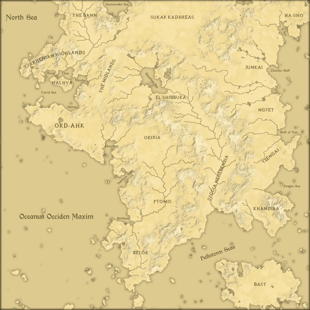
Note about this map: This is a finalized map of an earlier one (I think the first one posted in this thread). Pretty soon I'll put this in the Worldbuilding section when I can put down the setting in words. At the moment, I need sleep.Ninjadeadbeard's Extended Homebrew Originally Posted by Zap Dynamic
-
2012-05-26, 07:15 AM (ISO 8601)Ettin in the Playground

- Join Date
- Sep 2011
- Location
- An Abyssal Tower
- Gender
Re: Ninja Makes Maps
The use of the term Tyrrhenian leaps out at me.
May I enquire as to what inspired you to use that name?
One note: How volcanic is the region? You seem to have a large number of islands scattered throughout the sea that can't be reliably explained otherwise.
Okay, two notes: The method by which you've drawn your mountains leaves them rather ambiguous looking. Do they really contain as many inexplicable valleys and depressions as they appear to?
Aside from that nitpick, it's a great improvement over your earlier work. The rivers in particular look much more natural.
And yes, I know I said I'd post an image of a map, but I can't find any that are good enough to put up on the Internet and I find myself lacking the motivation to draw one.
It can, after all, take a while.Mauve Shirt, Savannah, Gnomish Wanderer, Cuthalion and Smuchmuch get cookies for making me avatars. (::)
(::) Current avatar by Smuchmuch (::)
Co Founder of LUTAS - For all your less than useful heroes out there.
My Deviant Art. Careful, it's full of ponies.
Dragons!
-
2012-05-26, 12:20 PM (ISO 8601)Bugbear in the Playground
- Join Date
- Apr 2011
- Location
- Unknown
- Gender
Re: Ninja Makes Maps
The setting is based on Late Antiquity, particularly the Roman Empire around the first century BC. Tyrrhenian was one among many names I grappled with looking for a good name for the "Roman" race. I eventually decided on it as the regional name (like how Rome was settled in Latium). I basically used the same name as a sea by Italy named for the Etruscans. Originally Posted by Elemental
It's probably volcanic as all-get-out. The northwest is a lot like Mediterranean-coast Europe, so there's a few Vesuvius' there. I want to say that the continental plate is pushing into another plate, leading to high volcanism and explaining some of the mountains as the continent rippling and buckling, but I'm not a geology major and haven't taken such a class in years. Does this sound reasonable?One note: How volcanic is the region? You seem to have a large number of islands scattered throughout the sea that can't be reliably explained otherwise.
They're meant to be mountain ranges, so I'd say yes they do. They do look odd though in a certain light. I'd rather not redraw them, but if they look really unnatural I might.Okay, two notes: The method by which you've drawn your mountains leaves them rather ambiguous looking. Do they really contain as many inexplicable valleys and depressions as they appear to?
Thank youAside from that nitpick, it's a great improvement over your earlier work. The rivers in particular look much more natural. . I actually tried to vary the river sizes here and there, with smaller inland rivers leading and merging into larger sea-bound rivers.
I totally understand. A lot of my earlier maps were drawn over several months, and I only just posted in bulk. Still, if you have an idea for representing forests, I'm still all ears.And yes, I know I said I'd post an image of a map, but I can't find any that are good enough to put up on the Internet and I find myself lacking the motivation to draw one.
It can, after all, take a while.Last edited by Ninjadeadbeard; 2012-05-26 at 12:22 PM.
Ninjadeadbeard's Extended Homebrew Originally Posted by Zap Dynamic
-
2012-05-26, 02:03 PM (ISO 8601)Bugbear in the Playground

- Join Date
- Jun 2011
Re: Ninja Makes Maps
The rivers seem to be improving.
I like that map, I think.
-
2012-05-29, 05:19 PM (ISO 8601)Titan in the Playground

- Join Date
- Oct 2008
- Location
- Freljord
Re: Ninja Makes Maps
I so want to see the rest of the world map on this one, seeing as the land trails off on the side. Originally Posted by Ninjadeadbeard
Homebrewer's Signature | Avatar by Strawberries
-
2012-05-29, 10:54 PM (ISO 8601)Bugbear in the Playground
- Join Date
- Apr 2011
- Location
- Unknown
- Gender
Re: Ninja Makes Maps
I might sometime, but it wouldn't be much. The map trails off primarily into the Arctic and Antarctic regions of the world. Originally Posted by Morph Bark
Ninjadeadbeard's Extended Homebrew Originally Posted by Zap Dynamic
-
2012-05-30, 08:07 AM (ISO 8601)Firbolg in the Playground

- Join Date
- Aug 2010
- Location
- Australia
- Gender

Re: Ninja Makes Maps
Your maps are awesome and I plan to try and use the method you wrote earlier in the thread.
If you are still willing to take requests, then I was wondering if you could make a map for my campaign setting.
I drew an amazingly basic map of it a year or two ago, would it be possible for you to make a map of your quality based off my bad one.
Here is a link to the image.Spoiler: Old Avatar by Aruiushttp://i133.photobucket.com/albums/q56/Zeritho/Koboldbard.png
-
2012-05-30, 03:07 PM (ISO 8601)Bugbear in the Playground
- Join Date
- Apr 2011
- Location
- Unknown
- Gender
Re: Ninja Makes Maps
It's honestly not that bad of a map. Just a question: What is Turvarn? Is it supposed to be mountains, desert? Originally Posted by Milo v3
Ninjadeadbeard's Extended Homebrew Originally Posted by Zap Dynamic
-
2012-05-30, 05:36 PM (ISO 8601)Firbolg in the Playground
- Join Date
- Aug 2010
- Location
- Australia
- Gender
Re: Ninja Makes Maps
Here is a section from the geography details on my setting: Originally Posted by Ninjadeadbeard
The Turvan is a huge set of Mountain Ranges. These mountains are so high that water frezes after a few minutes. The wind generally makes climbing these Mountains a fools task.
Dwarves and Durzites live deep inside these mountains, using the rich ore to build their cities. Because of the Dwarves and Durzites the Turvarn is riddled with maze-like tunnels. Many Creatures fill these caverns which causes most travelers to try and travel the Turvarn via Valleys on the surface. These valeys areas are all covered in a blanket of snow.
The Biggest City in the Mountains is the Durzite city of Ragna. Ragna utilizes Golems and similar constructs to expand on the city, without any danger to the Durzites themselves.Spoiler: Old Avatar by Aruiushttp://i133.photobucket.com/albums/q56/Zeritho/Koboldbard.png
-
2012-06-01, 01:31 AM (ISO 8601)Bugbear in the Playground
- Join Date
- Apr 2011
- Location
- Unknown
- Gender
Re: Ninja Makes Maps
Took me some time to work out all the kinks Milo, but I think you'll like this:
Spoiler
First in my usual style:
Spoiler
Second, a more familiar color selection:
Spoiler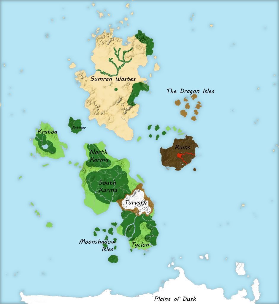
And finally with no names
Spoiler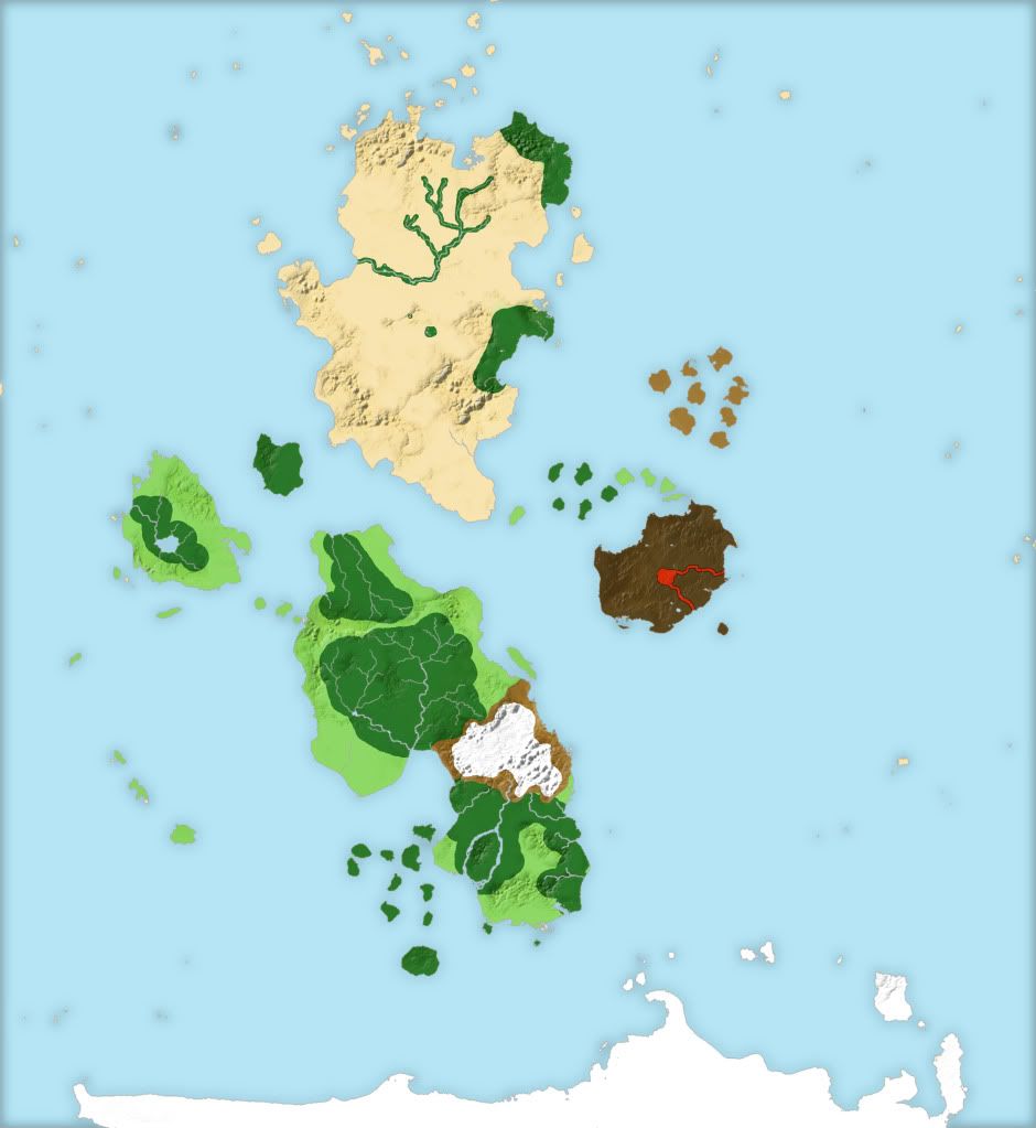
Ninjadeadbeard's Extended Homebrew Originally Posted by Zap Dynamic
-
2012-06-01, 01:34 AM (ISO 8601)Firbolg in the Playground
- Join Date
- Aug 2010
- Location
- Australia
- Gender
Re: Ninja Makes Maps
Thanks those are perfect.
Spoiler: Old Avatar by Aruiushttp://i133.photobucket.com/albums/q56/Zeritho/Koboldbard.png
-
2012-06-08, 06:26 AM (ISO 8601)Bugbear in the Playground
- Join Date
- Nov 2007
- Location
- As often as possible
- Gender

Re: Ninja Makes Maps
Your maps are amazing, I am very impressed with your work. The level of detail is marvelous. I'd like to see if I could make my own request for a map, if you have the time. I'm starting up a D&D game again and I realized I lost the old map, so I figured this might be a good time to completely impress my players. Let me know if you're available and willing and I can try to re-sketch it to give you something to work with ^_^
Gnomish Decker by me! You can find more of my work here!!! Also, my Tumblr, if you're into that
SpoilerYou fell for my firewall, chummer
The data highways are infinite and I've info left to tread
-
2012-06-08, 09:37 PM (ISO 8601)Bugbear in the Playground
- Join Date
- Apr 2011
- Location
- Unknown
- Gender
Re: Ninja Makes Maps
Oh, absolutely! I love doing maps, but lately school has taken up the bulk of my time. With finals coming up, I'm about to get a lot more free time. Just post a sketch and a little background info like terrain and I'll get cracking. Originally Posted by Gnomish Wanderer
Ninjadeadbeard's Extended Homebrew Originally Posted by Zap Dynamic
-
2012-06-09, 03:32 AM (ISO 8601)Bugbear in the Playground
- Join Date
- Nov 2007
- Location
- As often as possible
- Gender
Re: Ninja Makes Maps
Thank you, thank you! ^_^ I will be forever in your debt.
Terrible Map, my sketchSpoiler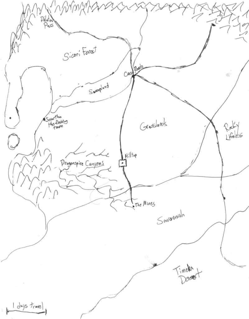
Description. I had to fight myself from spilling tons of unnecessary details that slipped in regardless. I sorry.SpoilerThe fertile lands are smack in the middle, revolving around the Kingdom of Hilltop surrounded by its grand walls.
To the north of Hilltop the ancient roads stretch upward to Crossroads, a tent town that sprang up within the edge of the swamp from demand, where the road splits into four. Keep following the road north and it'll stretch into the Sicori Forest, an impressive forest of thick trees that stretches out several days to the west and onto the peninsula that encapsulates an open-sea bay.
The road continues to the Mudin Mountains, the huge gash that separates the frozen dwarven war-plagued lands and holds out the cold. Here you'll find one of the only two safe passages through the mountains at the Dalatov Pass.
Back at Crossroads if you take the road going Northeast, you soon find the grasslands less hilly and becoming more thick, the grass seeming more choking here. If you keep following the road as it turns North you'll come to the Dwarven trade city of Dintag, the Mouth of the Dwarven Kingdoms where the two massive nations of southern Hilltop residents and Dwarven emissaries mingle. The only other known pass into the Dwarven Kingdoms.
Now on that Northeast road, before it turns more fully north to the Dwarven kingdoms, there is a strange trail bearing no grass. If you follow that for half a day, you'll find the City of Mirrors, Forudia. From the tallest tower of Forundia you can see the lifeless stretch of rocky infertile land that stretches to the east nearby.
The Southeast trail from Crossroads is quite a bit different. The hills stay constant for several days' journey, before finally the world seems to open up to a bleak rocky landscape that stretches to the east. It's within this lifeless zone you'll find Sartese, the ruins of an old civilization lost an era ago.
If you follow the road south life seems to be breathed into the land again as you reach the hot savannah, the trees and and grass sparse but larger animals less so. Here you'll find the town of Rovinspar, a wilder people only kept under Hilltop's power using force. And it seems not much longer the road becomes dotted with hills of rolling sand, barely visible in the near endless desert that stretches to the south and east. The road eventually becomes useless, which is why the kingdom far on the other side of the giant desert is rarely traded with.
Now if you were to take the south road out of Hilltop, the road is in much better repair and stretches south to the Mines on the outskirts of the savannah. The Mines themselves are a giant mining pit filled with rare minerals, a man-made gouge unlike the natural ones just to the west. The Dragonspire Canyons tear through the land, impressive rocky formations that sit maze-like in the land all the way west to the Shull Mountains, where the ancient Dragonborn kingdoms once sat. Streams of water snake through the floor of the canyons, providing yet another resource to both Hilltop and the Mines.
Just north of the Shull Mountains, when the land gets green and splentiful again, you run across the fishing town of Scaritha. Scaritha fishes the plentiful waters of the Roto Bay. They also get one of the impressive views of the Lifetree, a giant tree that roots in the middle of the mouth of the bay and stretches miles into the air.
I think that'll work, let me know if you want more detail. Perhaps I should have drawn the map at a smaller scale... Oh well. I really appreciate this!Last edited by Gnomish Wanderer; 2012-06-09 at 12:24 PM.
Gnomish Decker by me! You can find more of my work here!!! Also, my Tumblr, if you're into that
SpoilerYou fell for my firewall, chummer
The data highways are infinite and I've info left to tread
-
2014-04-21, 10:20 AM (ISO 8601)Barbarian in the Playground
- Join Date
- Jan 2014
- Location
- Under a Book
- Gender
Re: Ninja Makes Maps
Hi just wanted to say your awesome and I might have request for you soon. If you play Fire Emblem I would gladly do some sprites for you (any map, mug, battle, ect ..) in trade for you making me a map.
In any case your awesome Spoiler: My SigGames I'm DMing
Donvaor: Depths of Shadow : Recruitment/OC/IC
HomeBrew:
Scribble's Fire Emblem System
Credit to Elder Tsofu for the awesome avatar.
-
2014-04-30, 02:51 AM (ISO 8601)Ogre in the Playground

- Join Date
- Apr 2006
- Location
- WA, USA
- Gender
Re: Ninja Makes Maps
Is it possible to make a request for a map, based on a real world location?
Discord: Spacecamp-Logic-YakoSpoiler Originally Posted by bosssmiley
Former Avatar by Ceika, which I have long since lost a copy of.
-
2015-05-21, 09:36 PM (ISO 8601)Pixie in the Playground

- Join Date
- Apr 2015
- Gender
Re: Ninja Makes Maps
Hey, uh... I don't exactly have the time to make a map. So, can you build me a map? I'm not looking for much, maybe about half water and half land, and one continent needs to look somewhat like a dragon, and the other needs to look somewhat like a crescent. I'll need about five continents plus one subcontinent/island-Australia like thing.
I won't be able to play anything. Sorry. I'm a poor student. If I had a job I would pay. But then again, if I had a job, I wouldn't have to ration my money on Steam.
Thanks,
MetaLast edited by META_mahn; 2015-05-21 at 09:39 PM.

 Reply With Quote


 RSS Feeds: